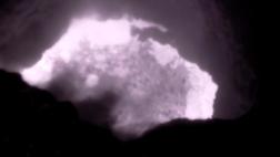
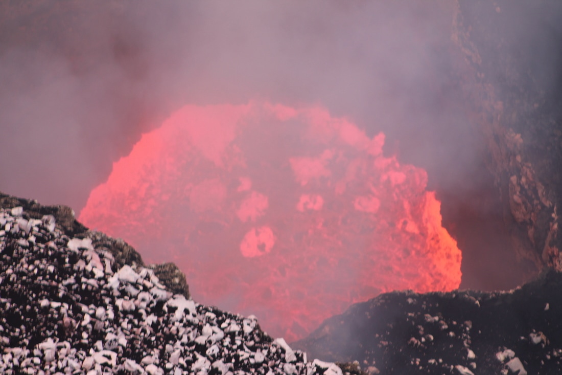
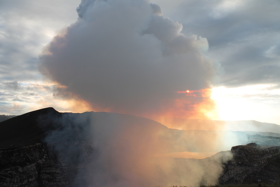
 Masaya lava lake captured using thermal imagery. The collapse of a portion of the wall can be seen in the top right. Masaya lava lake captured using thermal imagery. The collapse of a portion of the wall can be seen in the top right. Three days of (hopefully!) successful fieldwork under our belts and already we have managed to tick off a few of our goals of our list with four days of fieldwork left to go. We have had plenty of opportunity to get access to the summit area to measure the lava lake using our thermal camera and we had a pretty cool surprise when I processed some of the data in the evening. We discovered footage of a partial collapse of the lava lake wall into the lake (right), which I am sure I will post footage of soon. The lava lake really is mesmerising, it can be quite hard to tear yourself away from it, my brain trying to delve into some of the processes which appear to be going on. 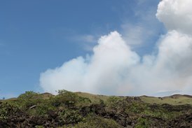 The plume at Masaya. The plume at Masaya. We have also conducted a fair bit of gas remote sensing of the plume (left) using our ultra violet (UV) cameras and have tested our spectrometer as well which are both designed for the measurement of sulphur dioxide (SO2) which this volcano appears to throw out in abundance. Something has to keep the lava lake vigorously over-turning! Masaya is actually quite a difficult location to find a good spot to measure the gas plume. Its low elevation means that the plume quite frequently hugs the ground, which isn't ideal for our measurements as it's best if we have clear sky on either side. Anyway we think we got a clear vantage point. So something I haven't spoken about yet is that the funding for this trip was helped by something called the GLOSS (Global Learning Opportunities in the Social Sciences) scheme at the University of Sheffield. This provides undergraduates the chance to work with academics on a research project. A truly fantastic opportunity, which I would have loved as an undergraduate! Some of the skills, whilst a lot to take on board in one go, e.g., how the equipment works, the protocols for measurement, and the 'fieldwork' aspect, are not covered in as much detail in a degree. For me, after a year of predominantly teaching, it has been great to be as research intensive as possible during this trip (bar a few admin duties). In short, a thoroughly enjoyable experience! Now off to the field for the day.  The centre of Granada. The centre of Granada. On Sunday we visited Granada, Catarina, and a cool viewing point of Volcano Mombacho which is situated on an old landslide. The scarp on the side of the volcano is quite obvious, although I don't think my picture quite manages to capture this (gallery below). Granada is an historic and colourful town, with the picture on the right taken from the top of the cathedral, showing the pleasant central square area. Although one of the stranger aspects was the setting off of pyrotechnics every 30 seconds, and I have no idea why! Sunday was our last day of waiting around, as we were reunited with our equipment on Monday morning. I must say it was a great relief, not knowing when you will get your equipment is very nerve-wracking and there was a voice in the back of my head saying 'but what if you don't get it back'. Thankfully not the case, and the Nicaraguan officials and our man on the ground in the local organisation INETER have all been fantastic. Getting into the park itself is easy with permission and the Nicaraguans rightly take security inside and around the park seriously. As soon as we got our equipment, the first thing we did was to head up to the summit area and the position where it is possible to make measurements of the lava lake. I do feel sorry for the tourists as it appears they don't get to come to the side that we can see! Today, we tested our thermal camera, and after an initial hiccough with our image capture software we managed to get some fantastic data of the turbulent lava lake. The camera has really worked better than I expected. We also attempted measurement of the gases from a spot nearby, but our position and the conditions were not great for this. We have some ideas about possible locations for UV camera measurements over the next few days. With all field campaigns it's great to get that initial day under your belt, to make sure the equipment is running after the journey and test out a few initial ideas to see what might work. This blog post also has an accompanying YouTube video, see below, if the video isn't available it is probably still uploading, as I need to get some sleep before Day 2 of fieldwork. 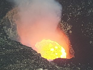 Masaya lava lake. Masaya lava lake. It's always a tiring journey travelling west but I tend not to struggle with jet-lag coming this direction, it's just a matter of keeping your eyes open - a job of increased importance when you have to drive from the airport after only 3 hours of sleep in the past 24 hours! It was a relatively smooth journey on the whole, and equipment seems to have arrived intact, but unfortunately we were not allowed to retain possession of it and take it into the country. It appears that a mix up in the customs department means that a letter giving us permission had yet to arrive, we therefore left the airport without our UV cameras, thermal camera, spectrometer and a couple computers. Somewhat vital equipment for our trip, but we will be reunited with our equipment today or early tomorrow.  Masaya volcanic plume. Masaya volcanic plume. We made our first ascent to the summit today (which you can just drive up the side to!), in preparation for when we do get our kit, and wow what a sight. I have wanted to visit and study a lava lake for a while and the awe inspiring view didn't disappoint. There is something slightly primeval about staring into a vigorously bubbling pit of lava. I have seen multiple videos of the lava lake but they really don't compare with the real thing. The picture on the left shows the large, rather condensed, plume of Masaya volcano. We will be measuring this using our UV camera equipment.
Meanwhile, my first impressions of Nicaragua are fantastic, a friendly people, and so far good food. The hotel/hostel we are staying in is basic but does the job and has a lovely interior courtyard for evening work and relaxation. Nicaragua is hot and humid, but the cold shower in the hotel makes up for this! Wondering round the streets of Masaya you are constantly greeted by the honking horns of taxis which seems to be their way of touting for custom. You also stumble across the odd shop with large amplifiers outside projecting Nicaraguan/Central American pop ditties into the street. Anyhow, a fantastic experience, and more from me soon. I write this short blog post in the seat of a taxi heading to Manchester airport. Gosh what an early morning! I am heading off to Nicaragua to study a volcano called Masaya and as ever on these trips I shall be blogging about the journey and the science that we are doing. I will also be doing a series of videos too, which I think I want to call "a diary of a volcanologist". So here is the first one, more from me soon! In October we published a paper on a new low cost method for measuring SO2 using Raspberry Pi Cameras and the Raspberry Pi platform, where we demonstrated its function at a power station, this was also the subject of my previous blog post. However, in this previous paper we had yet to test our camera against a commericial (and much more expensive!) UV (ultraviolet) camera to compare and contrast camera performance and error. This is an essential step which will give us confidence in the ability of our UV camera. We therefore took a commercial JAI camera system and our cameras to the flanks of Mt. Etna, one of the most reliable volcanoes to measure at, and spent a week measuring SO2 fluxes. This was during my "Back to Etna" blog posts during July '16. We conducted a number of tests including side-by-side measurements of degassing from the North-East Crater of Mt. Etna. This demonstrated that, following full processing (e.g., camera calibration using gas cells), both cameras produced almost identical flux traces. In addition, we tested and investigated a range of other parameters including signal-to-noise ratios and detection limits. We conclude that while the commerical camera may be slightly more sensitive in certain circumstances, our lower cost camera based on the Pi Camera should perform admirably for the overwhelming majority of volcanic applications. This is particularly significant given the large reduction in cost of our system (approximately 10 times cheaper) compared to a commerical grade one. The video below shows SO2 concentrations (higher concentrations are red colours) as imaged using the Pi Camera. The full published paper, which is Open Access was published in the journal Remote Sensing today "A Low-Cost Smartphone Sensor-Based UV Camera for Volcanic SO2 Emission Measurements". Finally, happy new year! 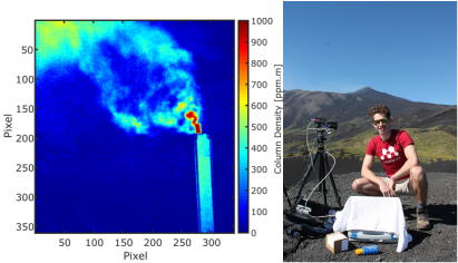 Left - Example image of sulphur dioxide emissions from a power station. The image was created using two different wavelengths of UV light. Right - Tom Wilkes on the flanks of Mt Etna with the Raspberry Pi UV camera system. Left - Example image of sulphur dioxide emissions from a power station. The image was created using two different wavelengths of UV light. Right - Tom Wilkes on the flanks of Mt Etna with the Raspberry Pi UV camera system. Last week our article "Ultraviolet Imaging with Low Cost Smartphone Sensors: Development and Application of a Raspberry Pi-Based UV Camera" was published in the Journal Sensors. The article is fully open access so can be downloaded in full! This work is the result of a continuing collaboration between the Department of Geography and the Department of Electronic and Electrical Engineering at the University of Sheffield, with the majority of the leg work done by current PhD student Tom Wilkes (Geography). In my last blog post, I talked about ultraviolet (UV) cameras, how they work, the improvements on previous techniques, and why we need them. However, the majority of current UV cameras are quite expensive! For a completely functioning system the costs may range anywhere between £10k to £50k. In our latest paper we detail a new method which uses the low cost Raspberry Pi camera and the Raspberry Pi computer to significantly reduced the costs of a complete UV camera system to perhaps <£500. There are also several other benefits of using the Raspberry Pi based set-up, including: a reduction in power needs, a reduction in the weight, and the ease of finding necessary parts. The majority of digital cameras and sensors such as the Raspberry Pi camera, when they are used unaltered, are sensitive only to visible light. This makes sense, as most of the time we want to take pictures which resemble what we see with our eyes! However, by removing certain layers from the surface of the camera sensor we can significantly increase the sensitivity to UV light at the wavelengths needed to measure the absorption of UV light by sulphur dioxide for example (see Figure above and video below for example application at a power station). There are also several other UV imaging applications which could benefit. The development of this new method also necessitated the purchase of new lenses (to focus the UV light onto the sensor) and the design of a new lens holder which was 3D printed. For full details see the published paper. Being a part of the development of this new method from the outset has been fantastic fun, and it is always amazing when everything turns out better than expected! 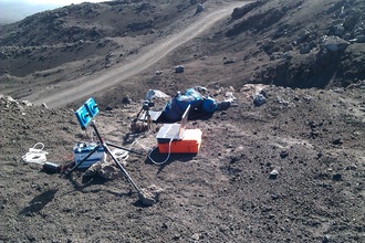 Ultraviolet cameras set up on the flanks of Mt. Etna. Ultraviolet cameras set up on the flanks of Mt. Etna. I have realised that I often talk about my work using UV (Ultraviolet) cameras on this blog but I have never properly explained how they work and why we specifically use them! So here I go. Monitoring volcanic gas release is one of the major things volcanologists can do to aid with eruption forecasting (see this recent post by James Hickey to understand why we call it forecasting). A number of techniques have therefore been developed and used to measure the release of volcanic gases from volcanoes. One of such techniques is the UV camera (Bluth et al. 2007; Mori and Burton, 2006), pictured on the right. These were developed to solve the time and spatial issues with previous techniques (e.g., DOAS and COSPEC). These previous techniques required building up a plume profile using a stepper motor to scan across a plume or traversing under it. Traversing could be conducted on foot, by moped, by car, or aircraft! The UV camera immediately solves this problem as it essentially works like a conventional camera by taking still images using the UV part of the electromagnetic spectrum, instead of visible light like your everyday camera. The UV camera and previous techniques all work on the principle of absorption of UV light by the volcanic gas sulphur dioxide (SO2). We specifically use SO2 due to the very low atmospheric background concentration of this gas. This makes it very easy to resolve the volcanic component. We can then, using two different cameras taking images at exactly the same time, compare two images (captured at the same time from each camera) where SO2 does and doesn't absorb (310 and 330 nm respectively). The graphic below illustrates the basic concept. 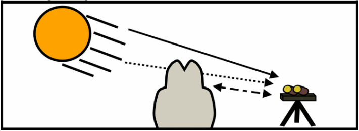 Graphic demonstrating the principle of ultraviolet spectroscopy. Incoming solar radiation (sunlight) is absorbed by sulphur dioxide within the volcanic plume. Light which isn't absorbed continues to the ultraviolet camera where the light intensity is recorded. 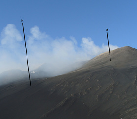 The plume from the NEC at Mt. Etna. Lines (a) and (b) indicate locations used to calculate plume transport speed. The plume from the NEC at Mt. Etna. Lines (a) and (b) indicate locations used to calculate plume transport speed. We can then use the Lambert-Beer law to combine the images captured at each wavelength to work out the strength of absorption in each pixel. At this stage the calculated value will preserve real fluctuations in concentration but we won't know exact SO2 values without calibration! There are two distinct ways of doing this. The first method is to image quartz gas cells, with known concentrations of SO2, with both cameras. We can then use the Lambert-Beer law again to combine the images at the separate wavelengths (310 and 330 nm - where SO2 does and doesn't absorb), which will create a series of new images with the absorption strength in each pixel - but this time we know exactly how much gas should be in front of the image - we can therefore use this to create what we call a calibration curve (or line) to map the values in the image of the volcanic plume to real SO2 concentrations. The second method is to combine the DOAS method (Differential Optical Absorption Spectroscopy) with the UV camera images. DOAS works in a different way, essentially measuring a single pixel in the plume, and it has the ability to determine actual SO2 concentration (based on the absorption structure of SO2 at different wavelengths). During acquisition the concentration of SO2 will change at the location the DOAS is pointing, again enabling us to calibrate our images through comparison of the absorption pixel values in the UV camera images for the same pixel with the known value. Both of these processes are illustrated in the photo slideshow below. We can then calculate the rate at which SO2 is released from a specific crater, vent or fumarole by multiplying the plume speed by the total concentration of SO2 contained along a single line (e.g., line [a] in the image above), what we call the integrated column amount. Plume speed can be determined in a couple ways, including: optical flow algorithms which map the movement of pixels from image to image (e.g., Peters et al. 2015) or by using a cross-correlation technique (e.g., McGonigle et al. 2005) which uses the structure of the gas plume and how long it takes for parts of the plume to move from one point to another (illustrated in picture of plume from Etna above as lines [a] and [b]). So this how we make UV camera measurements! The frequency that images can be taken is generally every 1 second but this can potentially be increased to 15 or even 30. This has the obvious benefit of being able to measure rapidly changing volcanic gas emissions associated with explosive activity such as strombolian volcanism or during passive activity (the constant quiescent release of gas). We can also begin to compare SO2 flux measurements with other datasets collected at similar time frequencies (e.g., Burton et al. 2015 offer an overview of UV camera studies). The benefits offered with an increase in spatial resolution can allow us to image more than one source at the same time - perfect where more than one crater (e.g., Etna) may be emitting gases or we may be observing a number of fumaroles (e.g., Vulcano). I hope this has been interesting aside into one of the major pieces of equipment which allows me to do my research! My next post will be all about a low cost UV camera system developed at the University of Sheffield and recently published in the Journal - Sensors. References
 Our view from measurement location. Our view from measurement location. Three days of fieldwork have passed since my last post, and what a mixed few days it has been. Sunday morning we got up to our previous measurement location on the flanks and the photo on the right was our view...not ideal measurement conditions for measuring a plume...especially if you can't see it! When faced with conditions like this in the field there are two options; either stick it out and see if conditions clear up or give up and clamber back down the mountain. This is the inspiration for my mildly creative blog title, it being the third post in my fieldwork series, as so far everything has gone well. That being said, we waited for three hours in the cold, wet and windy conditions till eventually the clouds cleared and we had a perfect(ish) view of the summit. Patience paid off! 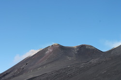 Very small ashy emissions from the New South East Crater. Very small ashy emissions from the New South East Crater. Fieldwork on Monday brought back memories from a field-trip to Etna I took during my Masters course at Lancaster University. We needed a new spot to measure from because of a different plume direction. When remote sensing a volcanic plume it is best if the plume isn't grounding, which unfortunately it has been doing a lot of recently. We decided to try a new spot on the edge of the Valle del Bove, a quite familiar 3 km walk undertaken during the Masters field trip which ends in a stunning view of one of the most impressive features on Etna (see images below). It also happened to have a decent view of the degassing craters with the plume appearing to drift towards Rifugio Sapienza. Apparently we missed a few ashy explosions on the Saturday from the New South East Crater, never mind, because we saw a couple during fieldwork on Tuesday, but they were quite minor (see image on the right). The arrival of colleagues from Palermo, with a 4 by 4 panda suitable of travelling to Pizzi Deneri provided an ideal location for remote sensing, and significantly less mileage by foot! One more day of work tomorrow, before the trip back to Palermo in our own faithful Fiat Panda. 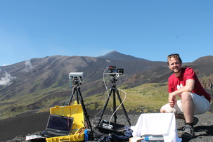 Remote sensing the plume of the NEC at Etna. Remote sensing the plume of the NEC at Etna. Rarely, rarely, rarely in a campaign do you get excellent data on the very first day you set out to make measurements. Today was one of those days. We set out with a goal to compare two different Ultra Violet (UV) camera systems, and on the first day it appears we have got the data to do this successfully. Although it is always good to gather more just to be sure! We were up early in the morning at 6 am to drive to Piano Provenzana for a short 30 minute walk to a good vantage point of the North East Crater (NEC) of Etna. See picture on the right. A familiar crater which has featured on my blog before and has provided a location for some previously published work. The NEC is often chosen as a location for UV work due to the high amounts of Sulphur Dioxide it emits daily. In the summer it is also easily accessible has much more reliable weather than other nearby sources such as Stromboli. There is also the added benefit of good food, wine, and sun. Below are a selection of pictures which I took during the day and my attempt at imaging some clouds over the summit of Etna last night. Unfortunately tomorrow it looks like a rainy and cloudy day on the summit, so it looks like it may be a day of data processing instead. 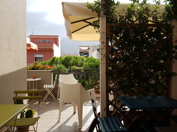 Rooftop breakfast at the B&B in Terrasini. Rooftop breakfast at the B&B in Terrasini. It has been two years since my last visit to Sicily, and that is definitely too many. This year is a little bit different. It is the first time I head off to do research not directly related to my own PhD with the specific purpose of helping a first year PhD student (Tom Wilkes) with an exciting new gas remote sensing project. A late flight in to Palermo meant a stay at a B&B in nearby Terrasini. I must admit that I had no idea what this area was like at all, so a bit of a gamble. But the gamble paid off, that is, once we had navigated all the many one way systems which were incorrectly labelled on Google Maps. A short walk from our B&B and there is a square filled with different options for food and drink. A late dinner and then back to the B&B ready for the morning journey to Palermo to pick up equipment for the journey to Linguaglossa. 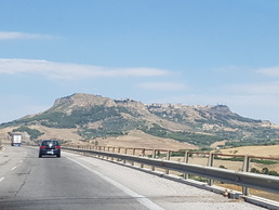 The journey from Palermo to Catania. The journey from Palermo to Catania. The driving is always an interesting experience. This is my third time driving in Italy, on the mainland around Naples/Sorrento and previously in Palermo. There is no acclimatising to the driving style. My ethos: expect anything to happen at anytime and that anyone may do it. For those who have done the UK hazard perception part of the driving test it is much akin to clicking the mouse constantly and furiously! That being said there is a certain enjoyment in driving under these more testing conditions. The journey from Palermo to Catania is fantastic, relatively empty roads through a semi-mountainous region, with amazing towns perched on hilly outcrops. I write this post from a lovely B&B in Linguaglossa, after an awesome and Norma Pizza, with a nighttime view of Etna in the distance. I think I might try some night time photography then it's early to bed before an early start tomorrow. 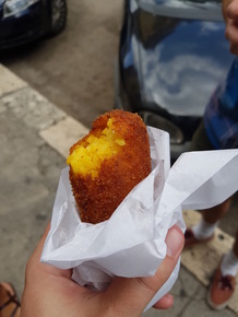 Arancini. Possibly one of the best food items in Sicily. |
 Archives
August 2022
|


 RSS Feed