|
Just a quick update post on the eruption of Popocatéptel in Mexico. The alert level has remained at Yellow Phase 3 although activity has subdued. Below is an image of the latest webcam taken from the CENAPRED website. We can still see clear steam emissions, although current ash content looks low. This is confirmed in the latest report on the eruption which states that in the 7 hours leading up to the report the eruption bursts were small with seven occuring during that time. An image of the largest of these bursts (at 800 metres high) is available here. There are also some photos of the eruption on the BBC website. 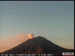
From a Cenapred webcam.
Popocatépetl is currently in the process of a light erutpion and as a result its alert status has been raised to Yellow Stage 3, which is the third highest alert status. The image below from one of the webcams is at 12:15pm GMT, with the plume just being caught by the sun you can see that the plume seems quite white in nature, which indicates that there is a large amount of steam in the plume itself. Popocatépetl is North Americas second highest volcano at over 5400m and derives its name from the Aztec language, which means 'Smoking Mountain'. In general, eruptions from Popocatépetl are fairly regular with around 10 eruptive episodes (which can span for many years) over the past 100 years. Erik at eruptions has also posted on this upgrade of alert status and gives a useful summary of the situation so far and a little bit about eruptions at Popocatépetl. Latest reports for the eruption can be found here. 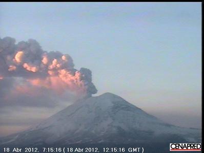
Have you ever wanted to step inside a volcano? This summer a tour company is offering the chance of travelling down into the magma chamber/lava tube system/shallow magma storage area of Thrihnukagigur volcano. This volcano was talked about in a post by Erik from eruptions at some point last year. Whilst there is some controvesy over what to call the area beneath the volano, there is no doubt that an opportunity for the general public to explore a feature such as this is brilliant and is something I would love to do myself! If any one can read Icelandic (which I can't I'm afraid!), there is a website here which gives some info and pictures and diagrams on the volcano and the area. There is some info on the volcano and the area in English here on the tour website. The video below gives a good overview of the size of the volcano and the gap underneath. I can't comment with any certainty on the matter having not visited myself (its always best to look at things in the flesh and be there, you get a much clearer picture and can make clearer judgements for yourself!), however I am going to put my 2 cents in about the crater itself anyway. As a cinder cone the type of activity at Thrihnukagigur volcano will be much like some of the episodes at Etna which have created cinder cones there over the years, and as such, present an interesting incite into processes below the surface during such events. The vivid colours inside the volcano demonstrate the high gas content and activity of the magma, further confirming the type of activity there. In certain volcanoes worldwide there are lava lakes and these can be seen to ebb and flow in height and activity, therefore we can accept that other volcanoes in similar situations will do this too and can often be seen as 'tide marks' of sort. It is certainly fortunate for us that the magma drained away (which there could be a few reasons why this happened) as we now have access to something quite beautiful and it does provide scope for research into the shallow plumbing systems of volcanoes. A while back this tour was featured in a TV program (National Geographic) and yes while some of these shows can be sensationalist (not all of them!) one thing they do very well is promote interest in the science behind them and encourage people to investigate further so they are not necessarily a bad thing. There are a host of video and even the National Geographic program on the website which are worth a watch if you have some spare time! A while back I posted on the Hidden Journeys project and a journey along the cascades. Today I thought I would put a brief post up with a little about the region and on one of the volcanoes which isnt talked about as much - Mount Hood. The volcanoes of the cascades arise because of the subduction of the Juan de Fuca Plate beneath its North American counterpart. From Mount Baker in the north to Crater Lake in the south the hazards these volcanoes pose are assessed by the Cascades Volcano Observatory (CVO) across the states of Washington, Oregon and Idaho. The remaining volcanoes to the south are assessed by the California Volcano Observatory (CalVO) In general, the research focus has centred on St. Helens due to the large amount of available and collected data as well as its relative ease of access. However there are many other important volcanoes in the area which shouldn't be forgotten! 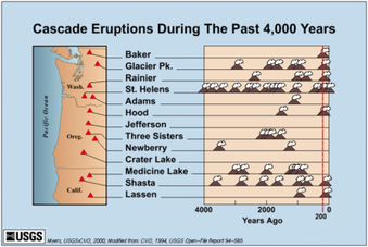
A USGS graphic to show the locations of the major volcanoes in the Cascades and when they have erupted.
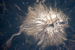 Image Courtesy of NASA: Mount Hood Mount Hood, pictured to the right, hasnt erupted since 1865 (although there are a couple of uncertain eruptions after this with the latest in 1907). Even though it hasnt erupted for over 100 years it still shows signs of activity from time to time - with events such as earthquake swarms beneath or near to the volcano and the instability of its slopes. A recent seismic swarm in 2002 allerted scientists to the possibility of volcanic unrest, however a study by Jones and Malone suggested that this earthquake was related to tectonic forces. Although they also stated that earthquakes situated directly below the summit could arise from volcanic unrest. For a good, brief overview of the Cascades and some of the volcanology/volcanoes of the region, I have attached the video from the Hidden Journeys project to my website which is worth a quick listen. |
 Archives
July 2023
|
 RSS Feed