|
With all the rigmarole surrounding what may or may not be happening at Bardarbunga, I thought I would put together a little guide of where to get RELIABLE information and comment. The main source of reliable information is, obviously, from the Icelandic Meteorological Office (IMO), update page here. The IMO really is the best and only source needed - primarily because they are the experts on Icelandic volcanoes and how they may or may not behave! For a detailed description of the area experiencing the unrest see this report on the volcanic system.
As with all volcanic activity there are a number of potential outcomes (for information on these see the IMO website update for the 26th August at 15:45), as such, any blogs or posts which pertain to one exact event happening are unlikely to be trusted! As always though the Eruptions blog by Erik Klemetti is a good and informative read. There are also quite a few nutters on Youtube these days, so I would be very careful what you watch there. Below is the twitter feed for the hash-tag Bardarbunga, which, among random posts, should show the most up to date news. Tweeters to look out for are @HTuffen, @Sim0nRedfern and @subglacial. This is of course not an exhaustive list! Don't forget to keep an eye on the webcams too! Links here and here, (the former link does not currently seem to be operational). 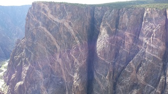 The painted wall - Black Canyon of the Gunnison The painted wall - Black Canyon of the Gunnison One of the fantastic things about driving round the US, especially in a state like Colorado is that there is often something unexpected round the corner. Originating in Denver we drove over the Rockies using US 285 (through a little place called South Park consequently - not many cartoon characters loitering around though!), then hitting the intersection at Salida we travelled west on highway 50. On the map, just before Montrose a small national park called the Black Canyon of the Gunnison was listed, having been in the car most of the day we thought why not take a look! It turned out to be an absolutely fantastic stop with fantastic views of a canyon filled with dikes here, there, and everywhere! The lighter coloured dikes here are pegmatite cutting into Gneiss. The park is surrounded by mountainous regions including the San Juans and the Elk mountain range. One small note, on entering the park we were all expecting to see a dark black canyon (e.g. as dark as some basalts), however, it is certainly more of a dark-to-light grey (although, it may turn a darker colour when the walls are wet...). Black Canyon of the Gunnison does have a much catchier feel to it than - Greyish Canyon of the Gunnison! We continued the journey through the San Juans on the million dollar highway, which is one of the most beautiful mountain passes I have been through, on our way to Durango. By the way in Durango there is an excellent restaurant (called Durango Brewpub) which served excellent food and excellent beer too. I will give fair warning though the chilli beer was certainly hotter than expected! OK, so the next location was extremely interesting, but not for the geology, the location? Mesa Verde national park (picture below of the Cliff Palace). Mesa Verde is the ancestral location of a number of current Native Indian peoples. The fantastic thing about these people is that sometime in the 1100s/1200s they started to move into these cliff dwellings underneath the overhangs (as pictured below) in response to changing environmental conditions. These really are worth a visit and I would thoroughly recommend the guided tours by the national park rangers to Cliff Palace, Balcony House and the Long House. During these you will learn a lot about the peoples who lived there, why they moved down and how they survived. Credit must really be given to the rangers who are very knowledgeable and really seemed to care about the location and the people. We were lucky to have three different perspectives from three different rangers with three different backgrounds: the first an archaeologist by training, the second an anthropologist, and the third a historian. 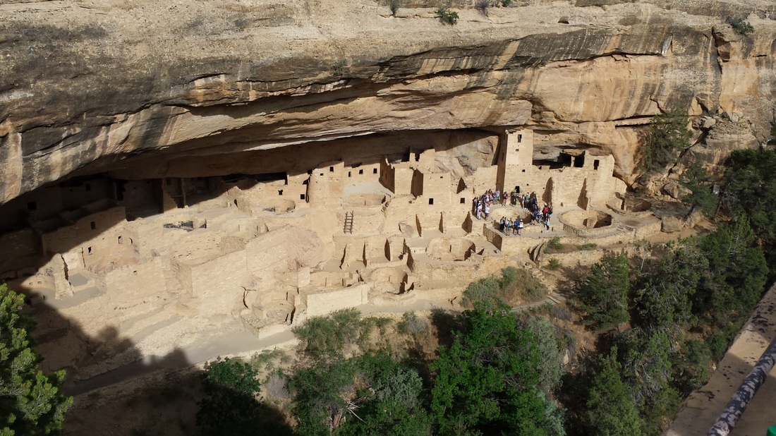
The Cliff Palace, Mesa Verde National Park
One more night in Durango and then the final stop on our trip, on the way back to Denver, was at the Sand Dunes National Park. This really is a surprising location, mostly because you really don't expect these rather large sand dunes (the tallest in North America) to appear out of nowhere! The picture below probably doesn't do them justice. On a vaguely volcanic note, theses Dunes are location a small distance (~100 miles) from the site of possibly the largest known volcanic eruption in history - that which created the La Garita Caldera. Climbing to the top of these dunes which are around 750 feet high was certainly harder than it looked! 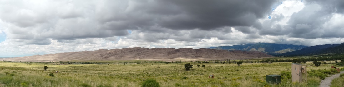
Sand Dunes National Park
|
 Archives
July 2023
|
 RSS Feed