|
The current weather conditions have spread the ash from Grimsvotn over parts of the UK airspace and as a consequence there are some delays being seen. The current height of the eruptive plume is at ~5 km. The figure below shows the projected position of the ash cloud at 0600, 1200, 1800 and midnight tonight. For today and probably tomorrow there will be significant delays to flights as many airlines will not want to take the risk. Whether there will be further disruption off into the future is more difficult to tell. 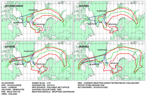 Taken from: http://www.metoffice.gov.uk/aviation/vaac/data/VAG_1306215801.png Current projections for the Grímsvötn ash are shown below. According to current info the plume is at ~13 km in height. Some regional flights have been cancelled in Scotland. 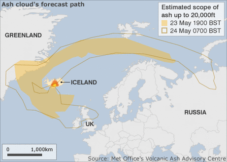 From the BBC website. 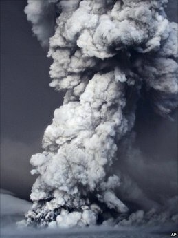 Taken from the BBC website., the 2011 plume. Yesterday I said that the Grímsvötn eruption would not affect air traffic in the UK and Europe. It now appears that the weather conditions indicate that some ash will be transported to the northern areas of Scotland and possibly Ireland as early as Tuesday morning. However the decreasing column height (~10 km) and the large size of the ash being produced tells us that any effect on air traffic (if any) will be small and not as widespread as last year.
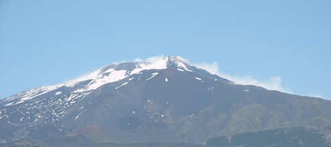
This illustrates the tempromental nature of volcanoes, volcanic eruptions and the weather and that nothing should be taken for granted as things can change momentarily! Grímsvötn, which is one of Iceland's most active volcanoes last erupted in 2004. The majority of Grímsvötn lies 200 m beneath the vast Vatnajökull ice-cap. Due to its location beneath the ice-cap there are several signs of an impending eruption and the volcanoes unrest. Melting of the ice by hydrothermal activity often causes what the Icelandics call a jökulhlaup which is a glacial outburst flood. Melting of the ice can also cause depressions of the ice surface. This 2011 episode started at ~17:30 UTC on the 21st May. Initially the eruption was contained benath the ice, but by ~21:00 UTC the eruptive cloud reached the surface and subsequently rose to an altitude of 20 km (~65,000 ft). It has currently closed the airspace in Iceland temporarily and a jökulhlaup is expected to be created as a result of the eruption.  Seismic activity indicates start of eruption after 17:30. So....the big question is. Will this eruption disrupt the air traffic in Europe like the eruption of Eyjafjallajökull in 2010? The answer, currently, is probably not. The current simulations are predicting that the ash will travel to the east and then north. There are also some unconfirmed reports that the activity is 'slowing down'. The following is a link to a webcam of the eruption, which may or may not be working! http://live.mila.is/grimsvotn/ An interesting fact about this volcano is that the Grimsvotn volcanic centre has fissures which trend through it NE to SW. One of these fissures is known as the Lake fissure, this fissure is renowned for its lava producing eruption of 1783 in which it released the the most lava seen and experienced by humans in recent history. It also released huge amoutns of Sulphur Dioxide causing an unusually hot summer for the time period. Overall, it caused widespread effects throughout Europe and is attributed to have killed ~30,000 people in Britain as a result. 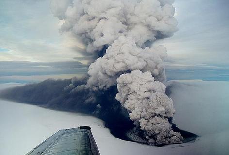 The 2004 eruption of Grimsvotn. Taken by Freysteinn Sigmundsson, 2004 and available from the Global Volcanism Programme. Thought I would share an image of a super-volcano in our own back yard. Glencoe is thought to be the site of a massive piece-meal caldera collapse brought on by a VEI 8 eruption. The image below shows two of the three sisters which are formations of ignimbrite. Ignimbrites are formed when ash and other various tephra from a pyroclastic density current weld to form a rock, they are often signs of very large eruptions. They can also be seen in the Scafell area of the Lake District in the UK and in areas such as Yellowstone, USA. 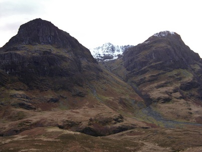 The three sisters ignimbrite. Glencoe, Scotland. Lava stalactites form when lava level in a tube drops and lava which has stuck to the ceiling begins to droop down. As it does so it cools, therefore forming stalactites! Below is an example from the Cassoni tube at Mt. Etna. 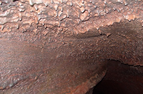 Xenoliths are one of the most important pieces of rock to come from volcanoes. They are fragments of material which are not part of an area of molten/solidified magma within a magma chamber or conduit. The area xenoliths come from is also known as the country rock. Xenoliths are important because of where they come from, they give us an insight into the rocks present deep into the Earth's interior and into those at shallower levels as well. Common xenoliths can include the rock basin underneath a volcano, to crystals sourced from the mantle - such as the green olivine and the black pyroxene. The picture below gives an example of a sedimentary xenolith found in a 2001 lava flow on Mt. Etna. It is from the base of Mt. Etna and tells us something about where the magma came from and whether it was part of the central conduit system or not. In this case the magma is from an eccentric eruption which rose quickly, enabling xenoliths to be present. 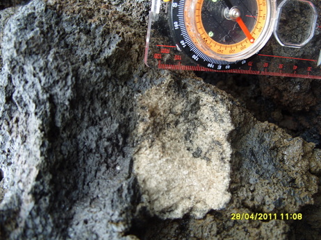 Thought I would share this image of a panorama I created of the Rifugio Sapienza area which was threatened by lava flows in 2001. On the far right is the scoria cone Upper Silvestri. In the far background is La Montagnolla, with the 2001 lavas above the building. 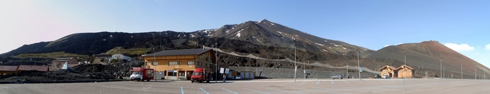 Rifugio Sapienza |
 Archives
July 2023
|
 RSS Feed