|
After spending a while trawling the internet and seeing some, to put it nicely, interesting articles/websites/posts, I have decided to write this post on exactly what would determine if an eruption is a 'super-eruption' and what makes a volcano a 'super-volcano'. There is much misuse of this terminology and they shouldn't be used willy nilly! To start, 'super-eruptions'. There are two volcanic scales broadly in use today. The Volcanic Explosivity Index (VEI) created by Newhall and Self, and a Magnitude scale similar to the Richter Scale. For an eruption to be classified as super on the VEI scale it must reach VEI 8, to do this a total of >1000 km3 of material needs to be released. On the magnitude scale which uses mass of material released a magnitude of 8 or 9 constitutes a super eruption. On this scale a M9 eruption is an extremely large eruption - of which very few have occurred, only one is currently known - the Fish Canyon Tuff in Colorado of the USA. Please note that under these scales Large-Igneous-Provinces or Flood Basalts would also be classed as 'super-eruptions' which they are not, despite their huge scale. Simply put a 'super-volcano' is a volcano which has experienced an eruption of high enough magmnitude (M8 or 9) or VEI (8) to allow characterisation as such. A volcano which has not experienced a 'super-eruption' is (in my opinion anyway) not a 'super-volcano' and always remember, just because a volcano has had a 'super-eruption' in the past, it does not 100% mean that it will have another! To come soon will be a new feature, book reviews! I am going to review books in the volcanological field, starting with Clive Oppenheimers new book: Eruptions that shook the world. The Santa Maria volcano awoke with a loud bang in the year 1902 with a large Plinian eruption that left a large crater in it's place. The eruption of 1902 billed as a possible VEI 6 eruption possibly killed as many as 5000 people. 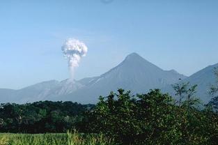 Photo: Lee Siebert. Santiaguito erupting beneath Santa Maria. Now, however the activity is located at the Santiaguito Volcanic Dome Complex at the base of Santa Maria and within the crater created by the 1902 eruption. Eruptions at this location started in 1922 and have been continuing to the current day. This complex currently consists of four dacitic volcanic domes with only one that is currently active the Caliente Dome. Santiaguito is famous for its consistent one to two hour vulcanian events. Other activity which occurs are Pyroclastic Density Currents, Lahars and an occasional larger event than its usual vulcanisn bursts. The most recent of these larger events occurred in 2010 and created a large ash column with associated Pyroclastic Density Currents and crater collapsing. The Santa Maria/Santiaguito complex recieved its Decade Volcano status because of the large hazard it poses to the population in Guatemala and the lack of funds locally to monitor and study the volcano sufficiently. For full details on Santiaguito and some interesting posts I thoroughly recommend the Magma Cum Laude blog. I have posted a video below from youtube of a typical event at Sanitaguito, the video itself was taken from the slopes of Santa Maria. Sakurakjima (Sakura-jima) another extremely active volcano of andesitic type is around 13,000 years old and until 1914 was a completely separate island, an eruption in this year filled the gap between the mainland. The volcano itself is situated within the large Aira caldera which formed around 22,000 years ago. 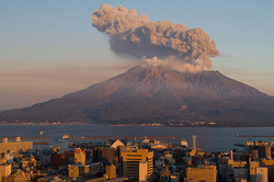 Taken from wikipedia, Sakurajima in 2009. Sakurajima has been in a state of persistent activity since 1955, mainly consisting of regular vulcanism eruptions. However in the past, Sakurajima has had several plinian eruptions, the latest coming in 1914 whilst an entirely effusive eruption occurred in 1946. The current activity at the summit comes from the Minami-Dake area whilst in the past, ending around 5000 years ago it has originated from Kita-Dake. It has been included as a Decade Volcano because of the potential dangers it poses to the voluminous numbers of nearby residents. Sources Global Volcanism Program Yamanoi et al. Color measurements of volcanic ash deposits from three different styles of summit activity at Sakurajima volcano, Japan: Conduit processes recorded in color of volcanic ash. Journal of Volcanology and Geothermal Research 178 (1), pp. 81-93 El Chichón volcano is located within the Chiapas region of South-East México at an elevation of ~1150 m (GVP, 2007). It is a remote andesitic stratovolcano in the Modern Chiapanecan Volcanic Arc (MCVA) with an ago of ~0.2 Ma years. El Chichón is at the most North-Western extent of the MCVA which is thought to be ~3 Ma years old (Manea and Manea, 2008; Simkin and Siebert, 1994). The closest volcano, Vulcan de San Martin, is 200 km to the North-West. El Chichón has been sporadically active during the recent Holocene period and in the geological record there are a minimum of 12 eruptions detected during the past ~8000 years; none of which are thought to have been larger than the 1982 eruption (Tilling et al. 1984; Macias et al. 2008). Historically the eruptions seen at El Chichón are a combination of lava dome and phreatomagmatic eruptions; the main hazards from eruptions are ashfall and column collapse causing PDCs (Pyroclastic Density Currents) (Tilling et al. 1984; GVP, 2007; Macias et al. 2008). The eruption which occurred ~600 years ago is thought to have played a part in the downfall of the Mayan civilisation!  The modern day eruption started suddenly on the 28th March 1982 at 23:22 local time with a plinian eruption column reaching to ~20 km (Sigurdsson et al. 1984; GVP, 2007). A max column height of ~27 km was recorded (Macias et al. 2008). This first major episode lasted until 0600 on the following morning and the population within 5 km of the volcano began to evacuate due to the high amount of ash falling as far as ~20 km away. During the following days there were a few minor phreatic eruptions recorded on the 30th and 31stof March (Sigurdsson et al. 1984; GVP, 2007).
Mount Rainier is a glacial covered stratovolcano situated on the western seaboard of the USA. It is the highest of the peaks at 4392 m in the Cascade Range and my personal favourite of the Decade volcanoes. 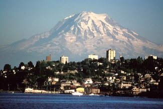 Taken by Lyn Topinka, Rainier with Tacoma in the foreground. With its towering position over the cities of Seattle and Tacoma it is seen a great hazard of the future, particularly with threat of lahars because of the large amounts of ice, and snow on its flanks and summit. This is the major reason for its inclusion as a Decade Volcano. However there are other hazards, in the past debris avalanches caused by the collapse of part of the edifice have travelled very long distances and can reach as far as the Puget Sound. An event such as this occurred around 5600 years ago in a similar but larger event to that which occurred at St. Helens in 1980. Of course a large eruption of Rainier would also be accompanied by the usual ensuing volcanic hazards (Pyroclastic Density Currents, Ashfall, Lava flows). The main edifice is around 500,000 years old and is composed of mostly lavas which have built up over time. It is unclear when Rainier last event minor event was with different souces stating different things! According to the GVP an event occurred back in 1894 which involved minor activity at the summit. It has been a while since any major activity has been seen, with up to VEI 4 events occuring in the past as is shown on the GVP. With a volcano such as Rainier any future eruption it is highly probable that it would be preceeded by warning signs such as deformation, hydrothermal activity and degassing increases. Despite the location of Rainier, there is a lot more work to be done on the volcano to understand its history and hence its potential future! 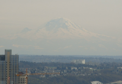 Rainier as taken from the space needle on a very hazy day! I am afraid that posts will be a little more sparse and irregular over the coming months due to an extremely busy summer (getting married and a dissertation to complete!), however I should get back to regular posting by the end of July! Sources USGS Global Volcanism Program Sisson, T.W., 1995. History and Hazards of Mount Rainier, Washington. USGS. Open-File Report 95-642. I thought I would do something a little fun today before continuing on with my posts on the Decade Volcanoes. Below is a mish-mosh of three volcanoes. Try and guess which ones they are! A few notes, the volcanoes may not necessarily be proportional... No prize, just for fun, bragging rights only! If I have a good response from this I will consider doing a weekly puzzle. 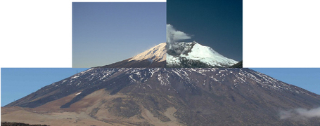 Nyiragongo, famous for its almost constant lava lake within the summit crater, it is a stratovolcano of the Virunga Volcanic complex in the East African Rift Valley and is probably the most dangerous in Africa. In total there are 8 mountains in the complex however Nyiragongo and the nearby Nyamuragira (picture below) are the only ones which remain active today. 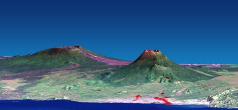 A topographically exaggerated image of Nyiragono on the right and Nyamuragira on the left. Lake Kivu is in the foreqround with Goma the light pink area on the shore of Kivu.The image is taken from the Nasa Earth Observatory available here - http://earthobservatory.nasa.gov/IOTD/view.php?id=2164 The two most important and devastating eruptions of Nyiragongo occurred in 1977 and 2002, both of these eruptions caused many fatalities. The eruption in 1977 completely and rapidly drained the lava lake on the 10th January 1977 creating rapid lava flows (up to ~60 mph in some cases) this rapidly overwhelmed the flanks and displaced many people present in Goma and on the flanks of the volcano. The lava lake then began to refill and on January 17th 2002 another eruption occurred when a fissure initially propogated from the top of the volcano (and later from the base) allowing the outflow of lava, the length of fissures totalled almost 20 km. Lava fountaining (or Hawaiian activity) was also present during this eruption. Another youtube video gives an excellent overview of the area around Nyiragongo and the eruption of 2002, available here. Sources Shuler and Ekström, 2009. Anomalous earthquakes associated with Nyiragongo Volcano: Observations and potential mechanisms. Journal of Volcanology and Geothermal Research 181 (3-4), pp. 219-230 Mavonga et al. 2010. Studies of crustal structure, seismic precursors to volcanic eruptions and earthquake hazard in the eastern provinces of the Democratic Republic of Congo. Journal of African Earth Sciences 58 (4), pp. 623-633 Global Volcanism Program John Seach Nasa EOS Quick eruption update: Actvity at Nabro has increased somewhat with the production of a new plume reported at Irish Weathre Online and by the Toulouse VAAC. This plume however is severely lacking in ash (evidenced by it's white colour) and contains large amounts of Sulphur Dioxide. For a detailed update please visit the Volcanism Blog for discussion and pictures! The eruption in Chile of Puyehue-Cordón Caulle is also causing major diruption to air travel as it continues. Whilst the renewed activity at Bocca Nuova on Etna continues with light ash emissions - from @etnaboris. Merapi which has featured heavily in the news recently, is one of the most active volcanoes of Indonesia, but more importantly one of the most hazardous in terms of threat to human life, hence it's designatin as a Decade Volcano. Mythology is very important to the locals around Merapi, who generally believe that Merapi is housed by spirits in various guises.  Merapi in 2005, from Wikipedia. Merapi, in central Java, is a stratovolcano which stands at ~2968 m tall. Due to the large amounts of people living within it's hazardous reach the Merapi Volcano Observatory keeps a watchful eyeover it's activity. It is the youngest of the volcanoes in the Java area and produces eruptions every 1 to 5 years of an andesitic type. The main hazards faced from eruptions of Merapi are the formation of Pyroclastic Density Currents (also called Pyroclastic Flows etc), a number of these are shown in the photos below, and lahars. Lava dome formation also occurs within the crater of Merapi and the collapse of these domes has caused the formation of Pyroclastic Density Currents frequently in the past. The most recent 2010 eruption has caused the deaths of more than 300 people. However the most devestating eruption occured in 1930 when more than 1000 people were killed by Pyroclastic Density Currents. 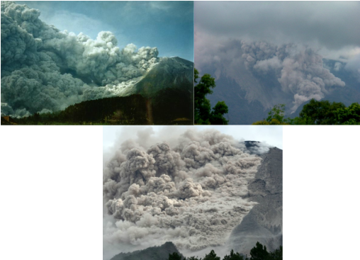 Left: a pyroclastic flow formed by lava dome collapse in 1994. The photo is available from the GVp and was taken by Panut. Right: Pyroclastic flow in 2006 from Wikipedia. Below: pyroclastic flow in 2006 from the GVP. Below is an unusual and amusing email I recieved via the contact form which I thought I would share with everyone. It certainly gave me a chuckle! Email Starts I have heard the following theories about the eyjafjallajokull eruption and would like youre opinion on the events.... 1. A meltdown of the Sun activated the volcano 2. Secret experiments with ‘seismic weapons’ 3. Closing in on the end of the Mayan calendar 4. Manoeuvres at an alien landing site 5. Discreet terror attack response exercise 6. The Earth is beginning to heal itself 7. Preliminary warning of a mega poison cloud 8. Beginning of a new super eruption 9. The interior of the Earth is collapsing 10. Fulfilment of age-old Nordic legends Thanks Dr. Ignim Brite Email Ends Which one is your favourtie? Let me know! Mauna Loa, a shield volcano of Hawaii, is the largest volcano on Earth with a volume of 80,000 km2. At ~4170 m above sea level it is not the tallest, however when you take into account the ~5000 m it stretches from the sea bed to sea level a grand total of more than 9000 m is obtained, which, if it wasn't for its neighbour Mauna Kea (at ~10,000 m) would make it the tallest volcano as well! Due to its size and weight it has also pushed down its base by a further 8 km, not a true height, but extremely interesting! 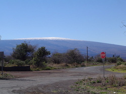 Mauna Loa This volcano was formed by a mantle plume (or hot spot) and evidence of the plume position can be seen at the surface and in the sea as the Hawaiian-Emperor Seamount Chain. As the Pacific plate moves and the mantle plume stays in roughly the same area a series of islands is created. In geological time, Mauna Loa is also relatively young at 200,000 years old and will probably become extinct within the next 500,000 to 1 million years. At the summit of Mauna Loa is the current Mokuaweoweo caldera around 5 km long and 3 km wide within an older and larger caldera. The last eruption of Mauna Loa occured in 1984 and was characterised by the usual mild explosive and effusive characteristics that are commonly seen on Hawaii. This included lava flows (aa and pahoehoe), hawaiian acitvity (fire fountaining) and strombolian activity. 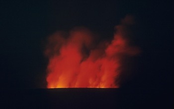 Night time photograph of the 1984 eruption. This post has probably not done Mauna Loa justice as it is an extremely interesting volcano with a more diverse history than can be fit into one post! There are many good sources of info including the Global Volcanism Program and the Hawaiian Volcano Observatory. Galeras in Colombia is one of the most active in the country and has seen regular eruptions for the past 1 million years. With 7 eruptions since the turn of the century and one occuring in 2010 the activity hasn't stopped since. The 2010 activity caused the evacuation of 8000 people from its vicinity. A nice overview of the area is available here at the NASA Earth Observatory. 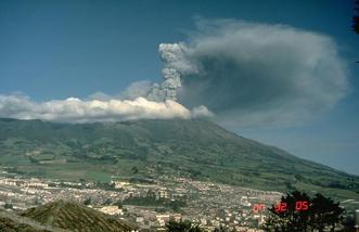 From the GVP page for Galeras. Galeras at ~4276 m high is a stratovolcano which towers over the town of Pasto and produces predominantly andesitic products. The reason for volcanism at this location is the subduction of the Nazca plate. A nice diagram of this is shown here. The summit of Galeras is complex as it has had a diverse and extremely interesting history, involving a couple of caldera forming events, one which occurred 500,000 years ago and the other around 100,000 years ago. In addition to these events a series of edifice collapse episodes have left a horseshoe shape at the summit. Since the first historic eruption was recorded by the Spanish in the 16th century, the volcanism has been lightly explosive, producing ash clouds and pyroclatic flows in what can be described as vulcanian to sub-plinian events. This volcano became infamous in 1993 when it sadly killed nine people (six of who were scientists) who were in the summit crater at the time of the eruption. Prior to this sad event, Galeras was designated a Decade Volcano in 1991. Other Volcano News Today is the 20th anniversary of the eruption of Pinatubo in 1991. Over at the Eruptions blog by Erik Klemmeti there is an excellent anniversary post, I reccomend you check it out! |
 Archives
July 2023
|
 RSS Feed