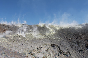
 Summit fumaroles at Vulcano Summit fumaroles at Vulcano Vulcano is one of the most fantastic destinations I have had the chance to do fieldwork so far. Combine an easily accessible summit (on the right), persistently active fumaroles and amazing summit views, with great food and the result is a most enjoyable and productive field session. Another great thing about Vulcano as a target for remote sensors like me is that it is relatively accessible all year round (subject to somewhat erratic boat timetables) and it is less subject to inclement weather conditions. This is something that nearby volcanoes Etna and Stromboli suffer from greatly especially during winter months. However, this is certainly not to say that Vulcano doesn't have its challenges when making measurements because it certainly does! For this particular session we were taking a variety of spectroscopic measurements of the summit fumaroles (first photo on the right) using ultra-violet cameras (see Tamburello et al. 2011 for previous measurements at Vulcano) and transecting the fumaroles using a MultiGAS unit (see Aiuppa et al. 2005; Shinohara, 2005). A MultiGAS unit sucks in surrounding air through a tube and analyses for the concentration of a number of volcanic species (e.g. sulphur dioxide, carbon dioxide etc), it can do this at an extremely high resolution of approximately every 2 seconds. To continue with my previous thought, what are these challenges when making measurements? Well first and foremost when using ultra-violet and other spectroscopic systems, for the most accurate of measurements a number of conditions need to be met:
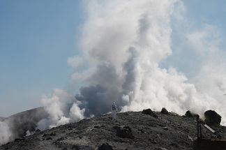 Transecting the plume. Transecting the plume. To the left is the merged plume of a number of the fumaroles early on one of the mornings. As you can probably observe, the plume is a little too condensed at this stage...but a few hours of waiting and conditions improved to become almost perfect (as above). In the centre of the image you can just about make out a solitary figure clad all in white. This figure is just about to enter the plume and perform a transect of the upper crater terrace fumaroles using a MultiGAS unit. When transecting the plume it is necessary to where goggles and a gas mask to protect against the high concentrations of toxic gases. The first thing you notice when you reach the vicinity of the plume is a faint rotten egg smell (hydrogen sulphide). Anyone who has stood in the vicinity of such gases will know that one of the first noticeable effects, even at relatively low concentrations, is the irritation of respiratory tracts. This can often result in quite a bit of coughing! 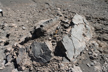 A sizable bread crust bomb in the crater. A sizable bread crust bomb in the crater. Of course Vulcano is a great place for more than just the summit fumaroles, previous historical eruptions (e.g. the eruption of 1888) have thrown up some quite spectacularly sized bombs with a large number of them the appropriately named bread-crust bombs which are scattered around the place. After stumbling across a book: Vulcano, Tre Secoli Di Mineralogia (Three centuries of minerals). in a little restaurant called Maurizios (which I highly recommend!), I learnt that there were in fact minute amounts of gold found in the fumaroles of Vulcano. However, don't pack your bags, and shovels yet, the amounts present would certainly not be enough to make you rich very quickly! In the photos at the bottom of the post you can see the plume of Stromboli, taken with a canon 300 mm zoom lens and a couple of the surrounding Aeolian Islands. You can find a few more photos in this section on my website! 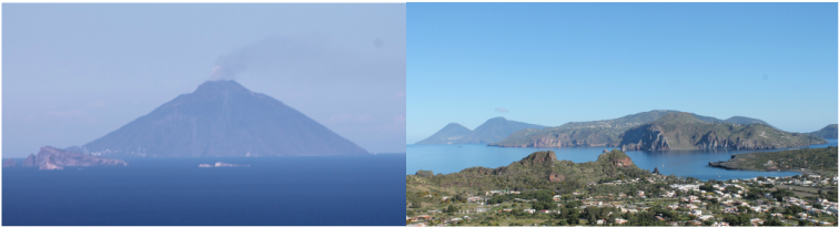 Left: Stromboli visible from the crater terrace of Vulcano with visible plume. Right: civilisation on Vulcano in the foreground, Lipari in the centre and Salina rear-left. 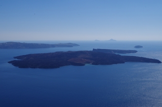 Nea Kameni, located almost centrally in the caldera Nea Kameni, located almost centrally in the caldera Thanks to Tom for inviting me to contribute this blog-post. I should start by telling you a little about me and how I know Tom, so here goes. I am a PhD student at Royal Holloway, University of London, researching volcano-tectonics and specifically the mechanics of caldera collapses. Like Tom I also studied for a Master’s degree in Volcanology and Geological Hazards at Lancaster University, although we did not meet at Lancaster. I first met Tom in May 2013 for a NEMOH organised field school at Stromboli volcano; where we jointly experienced an unfortunately unforgettable, and particularly rough boat back to the mainland of Sicily. I can highly recommend that if the captain of a sketchy looking boat offers to get you off an island when none of the main companies are willing to, think again! So, Tom asked me to write this post as he heard that I was working at a really fascinating and important volcano in Greece. The volcano in question is Santorini, which is a particularly famous stratovolcano in the Aegean ocean. The volcano is famous partly because around 3500 years ago the island experienced a huge caldera forming eruption, which is believed to be associated with the demise of the Minoan civilisation. Deposits from the various phases of the eruption can be seen straddling almost the entire circumference of a north-south elongated caldera, which measures approximately 10 km in maximum diameter, several hundred metres in depth and is centrally filled by ocean. In fact, at least three huge eruptions, ~100 thousand years, ~21 thousand and ~3500 years ago contributed to the shape and size of the current caldera. The global impacts of the Minoan eruption have often been overestimated (see the article of Pyle, 1995), however in terms of volume this eruption is up there with the biggest of the past 10,000 years. Active volcanism in Santorini is now constrained to a small island named Nea Kameni, located almost in the centre of the caldera. This resurgent volcano has been the site of several predominantly effusive eruptions, the latest of which occurred in 1950. Importantly, the island of Santorini lies on top of two north-east to south-west trending faults, one in the north of the island is called the Colombo fault and the other which is believed to be associated with the current phase of volcanism lies directly under Nea Kameni, and is named the Kameni fault. 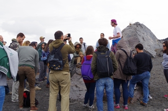 Giving a lecture in the field. Giving a lecture in the field. OK, so what was I doing in Santorini? The answer is looking for and studying dykes in the caldera walls. Just so you’re up to speed, a dyke is a magma-driven fracture through which all volcanic eruptions must be fed. As such, it is really important to know the conditions for dyke propagation in a volcanic edifice. Luckily there are many fantastic geological locations (e.g. Iceland/Tenerife) around the world where geologists can see deep inside ancient volcanoes. In doing so it is possible to observe that many dykes (if not most) never reach the surface, and therefore never contribute to a volcanic eruption. They become arrested. Santorini is a stratovolcano made up of many layers of contrasting mechanical properties; for example, stiff lava flows and comparatively compliant layers such as ash, volcanic tuffs and breccia’s. So it offers a great opportunity to try to understand how dykes pass through these individual layers. Specifically, I went into the field to take measurements on the thicknesses, directions and compositions of individual dykes. The walls of the caldera are very steep and largely inaccessible, so most of my work was conducted from a boat, which was a really cool experience. The data is important for me because I am trying to understand how calderas form in different volcanoes. I am using the propagation of dykes as a proxy for the propagation of caldera fractures, because presumably the fracture which created the current caldera must have passed through the same materials with which these dykes also passed. 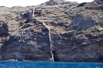 A dyke cuts through several different layers in the caldera wall A dyke cuts through several different layers in the caldera wall In 2011, Santorini experienced an unrest period characterised by elevated levels of seismicity and uplift (see Parks, 2012 for details). Such signals are most likely associated with magma being transported as dyke from great depths, to recharge a shallow magma chamber. When and why a magma chamber ruptures and sends a dyke to the surface is still a reasonably poorly understood phenomenon. So the important question at most caldera volcanoes is: when does a period of unrest lead to a volcanic eruption? It is a difficult one to answer! As well as gathering data for my PhD I also took the time to help out at the run-off erosion intensive field-course organised by the University of Athens. Sandy Drymoni and I ran the course’s final day visit to Nea Kameni, where we introduced some basic volcanological concepts and described some of the islands features. This was a very rewarding and enjoyable experience. The previous day I also had the opportunity to meet the mayor of Santorini at a visit to the Minoan ruins at Akrotiri. Although I wasn’t able to question him about the island’s volcanic preparedness, this was partly out of courtesy, but mainly because we didn’t speak any of the same languages. I will now use the data collected from this fieldwork as an input for numerical models using the structural mechanics module of a program called COMSOL. In doing so, I will try to understand the stress conditions required for dyke propagation; caldera formation and magma chamber rupture in different types of volcanic edifice. 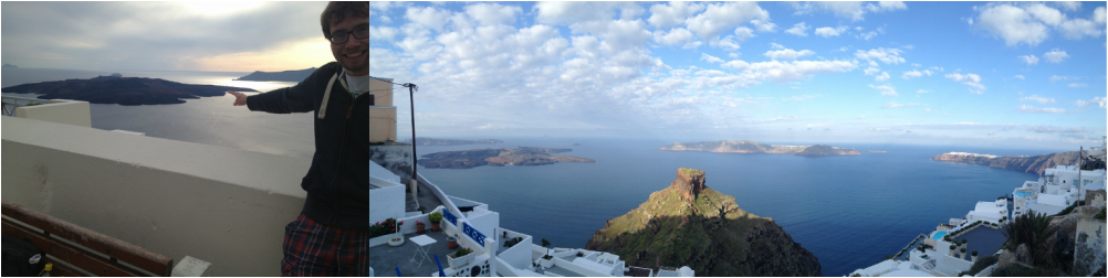
Left: pointing out Nea Kameni. Right: view west into the caldera from Imerovigli
The receival of a last minute NERC Impaft Fund has meant a mad dash to be ready for a sampling session at Vulcano. The volcano which all others take their name! I am quite excited about adding another volcano to my growing list. So....what do I do to prepare for fieldwork. One of the first things you do is check all the main equipment is working! In this case, I am developing a new technique which means a brand new Matlab Application finished the Friday before I leave! Hopefully its suitably free of bugs! Next I list the equipment I need, check I know how to use it and I have plenty of spare batteries. As always, last minute clothes packing and as always I forget one thing...this time it was deodrant... Vulcano is one of the Aeolian Islands (which includes Stromboli, Lipari) and is fantastic for remote sensing for the majority of the year because of generally good measurement conditions and persistent fumaroles at the La Fossa Crater! Its easily accesible by boat from Milazzo. So, here I am writing this blog on the pier in Milazzo after surviving two days of driving in Palermo (one Italian told me if you can drive in Palermo you can drive anywhere) and the North coast of Sicily! I am going to try and do a little bit of tweeting/blogging from the field if I have time! 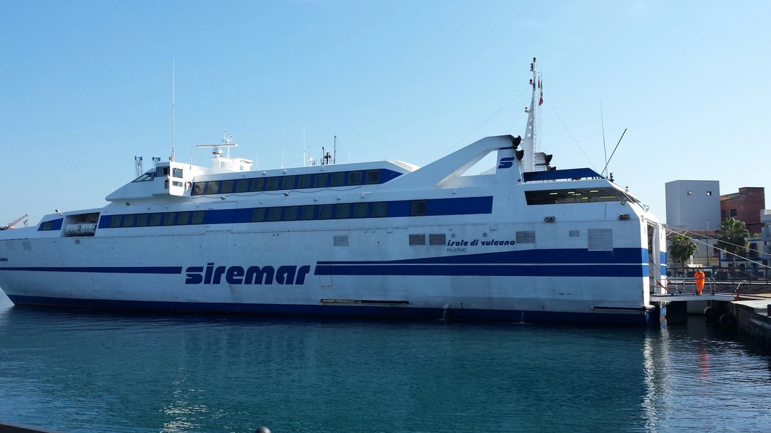
The boat to Vulcano
|
 Archives
July 2023
|
 RSS Feed