|
El Chichón volcano is located within the Chiapas region of South-East México at an elevation of ~1150 m (GVP, 2007). It is a remote andesitic stratovolcano in the Modern Chiapanecan Volcanic Arc (MCVA) with an ago of ~0.2 Ma years. El Chichón is at the most North-Western extent of the MCVA which is thought to be ~3 Ma years old (Manea and Manea, 2008; Simkin and Siebert, 1994). The closest volcano, Vulcan de San Martin, is 200 km to the North-West. El Chichón has been sporadically active during the recent Holocene period and in the geological record there are a minimum of 12 eruptions detected during the past ~8000 years; none of which are thought to have been larger than the 1982 eruption (Tilling et al. 1984; Macias et al. 2008). Historically the eruptions seen at El Chichón are a combination of lava dome and phreatomagmatic eruptions; the main hazards from eruptions are ashfall and column collapse causing PDCs (Pyroclastic Density Currents) (Tilling et al. 1984; GVP, 2007; Macias et al. 2008). The eruption which occurred ~600 years ago is thought to have played a part in the downfall of the Mayan civilisation! 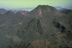 The modern day eruption started suddenly on the 28th March 1982 at 23:22 local time with a plinian eruption column reaching to ~20 km (Sigurdsson et al. 1984; GVP, 2007). A max column height of ~27 km was recorded (Macias et al. 2008). This first major episode lasted until 0600 on the following morning and the population within 5 km of the volcano began to evacuate due to the high amount of ash falling as far as ~20 km away. During the following days there were a few minor phreatic eruptions recorded on the 30th and 31stof March (Sigurdsson et al. 1984; GVP, 2007). The second major episode occurred on the 3rd April at around 03:00; this was the most deadly episode in cost to human life, it generated large amounts of ashfall on the flanks of the volcano, particularly in the village of Nicapa, which received an additional 7.5cm of ashfall (Sigurdsson et al. 1984; GVP, 2007). These effects were produced by an eruption column which reached a maximum of ~32 km (Macias et al. 2008). In addition to ashfall PDCs were also present; they devastated a broadly circular area of ~153 km2, this lead to the destruction of 9 small communities and villages within a distance of ~6 km from the summit (Sigurdsson et al. 1984). The third, largest and final episode of the eruption started at 05:22 on the 4th April with the primary hazard of ashfall, with a few PDCs (Sigurdsson et al. 1984; GVP, 2007). The strongest effect was the large amounts of sulphur which were released into the stratosphere (Robock, 2000) from a max eruption column height of ~29 km. There was little loss of life during this episode. After the eruption, the summit crater and lava dome were destroyed and in its place a new crater around 1 km and 300 m deep was formed within the newly formed crater a lake formed from rainwater (GVP, 2007). 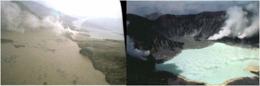 Taken from the Global Volcanism Program, the image on the left shows the volcanic dam which was formed and ruptured on the 26th May (Servando De la Cruz-Reyna). The image on the right shows the crater lake after the eruption in 1983 (Bill Rose). The most widely researched global effect of the eruption involves the large amount of particulates and sulphur dioxide (SO2) emitted into the stratosphere. Between ~5 and 9 million tons of SO2 were released, (Rampino and Self; 1984; Luhr, 2008) which circled the globe in 3 weeks (Robock, 2000), ~20 million tons of particulate matter was released (Robock, 2000), this is believed to have caused warming of the stratosphere (and hence a slight cooling of the troposphere). One of the most interesting aspects of the eruption is the formation of the volcanic dam which is shown in the picture above. There were multiple lakes in the area formed in this way, however, the one indicated was formed when PDCs blocked the River Magdalena South-West of the summit crater (GVP, 2007). This dam had a height of 55 m and is thought to have grown to ~5 km in length and contained several million m3 of water before rupturing 2 months after its formation (Macias et al. 2004). On the 26thMay 1982 the dam ruptured and sent a hot lahar downstream (GVP, 2007). Around 11,000 m3 of water was released for the first hour; the dam was fully drained after a further hour. The lahar eventually reached the Penita Hydroelectric dam, where the only noted death occurred, as well as three injuries caused by the temperature of the lahar (GVP, 2007). References/Sources Global Volcanism Program (GVP) Luhr, J.F., 2008. Primary igneous anhydrite: Progress since its recognition in the 1982 El Chichón trachyandesite. Journal of Volcanology and Geothermal Research 175, pp. 394-407 Macias, J.L., Capra, L., Arce, J.L., Espindola, J.M., Garcia-Palomo, A., Sheridan, M.F., 2008. Hazard map of El Chichón volcano, Chiapas, México: Constraints posed by eruptive history and computer simulations. Journal of Volcanology and Geothermal Research 175, pp. 444-458 Macıas, J.L., Capra, L., Scott, K.M., Espindola, J.M., Garcia-Palomo, A., Costa, J.E., 2004. The 26 May 1982 breakout flows derived from failure of a volcanic dam at El Chichón, Chiapas, Mexico. Geol. Soc.Am. Bull.116, pp. 233–246 Manea, M., Manea, V.C., 2008. On the origin of El Chichon Volcano and subduction of Tehuantepec Ridge: A geodynamical perspective. Journal of Volcanology and Geothermal Research 175, pp. 459-471 Rampino, M.R., Self, S.,1984. Sulphur-rich volcanic eruptions and stratospheric aerosols. Nature 310, pp. 677–679. Robock, A., 2000. Volcanic Eruptions and Climate. Reviews of Geophysics 38 (2), pp. 191-219 Sigurdsson, H., Carey, S.N., Espindola, J.M., 1984. The 1982 eruptions of El Chichón Volcano, Mexico: Stratigraphy of pyroclastic deposits. Journal of Volcanology and Geothermal Research 23 (1-2), pp. 11-37 Simkin, T., Siebert, L., 1994. Volcanoes of the World, second edition. Geoscience Press, Tucson. 349 pp Tilling, R.I., Rubin, M., Sigurdsson, H., Carey, S., Duffield, W.A., Rose, W.I., 1984. Holocene eruptive activity of El Chichon volcano, Chiapas, Mexico. Science 224, pp. 747-749
college park middle school
16/2/2012 05:54:07 am
you peoples need more freckin information!!! ight ;) Comments are closed.
|
 Archives
July 2023
|
 RSS Feed