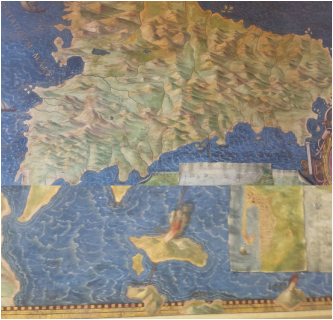
 Sicily. Etna can be seen on the left hand side of the image. Below a zoom of a portion of the Aeolian Islands. Vulcano can be seen but also a mysterious Felicur. What is this erupting volcano? Sicily. Etna can be seen on the left hand side of the image. Below a zoom of a portion of the Aeolian Islands. Vulcano can be seen but also a mysterious Felicur. What is this erupting volcano? The city of Rome is filled with some of the worlds most fantastic art by equally some of the most famous artists: Da Vinci, Bernini, Michealangelo...the list goes on! Many of these are contained within the catholic churches in the city of Rome. Many are also contained in the Vatican Museums, of which, I had not read anything about before visiting. The Gallery of Maps was a complete and welcome surprise. The Gallery of Maps is a long corridor covered from top to bottom with frescoes of the Italian area. The maps were created between 1580-1585 by an Ignazio Danti and by and large they show a relatively accurate representation. Of course any map of the region wouldn't be complete without the volcanoes, which are, of course, duly depicted! But are these volcanoes depicted accurately? Etna, a frequent topic of my blog, and an integral part of my research is shown quite clearly (image above), although not in enough detail to make out the individual craters, merely that it is an exploding mountain! It is logical to assume that all volcanoes with fire or smoke coming from the summit (as in Vesuvius, not pictured here) are active or have been known to be active in the past. 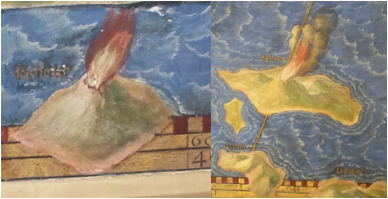 Felicur (see post) on the left and Vulcano on the right. Felicur (see post) on the left and Vulcano on the right. A large portion of the gallery was covered with scaffolding. However, visible were two other map portions containing volcanoes - both depicting the Aeolian Islands (pictured at bottom and to the right). The pictures to the right are taken from a section of the map which looks at only Sicily and surrounding islands. The picture below is a broader overall picture of the region. In the bottom picture we see two volcanically active islands Vulcano and Stromboli (Strongule on the map). Data from the global volcanism program suggests, see Vulcano page here, that there were events around that period, and it is also reasonable to assume that the crater terrace area would be similarly active with fumaroles as it is today. It is also comforting to see that Stromboli is also depicted as active. Stromboli has been throughout the centuries as active in a similar form to that seen today. The paintings in the middle show Vulcano on the right and a location called Felicur on the left. What is this Felicur? It doesn't match the previous (latin) names of Stromboli, could it be Filicudi? If so, one look into the history of Filicudi suggests it hasn't erupted for 1000s of years. So perhaps the painter got the name wrong and it is actually Stromboli. Or am I missing something obvious? Please point it our if I am! It's position on the overall map does suggest that it is not Stromboli (see image at start of the blog post), as it is in generally the wrong position (which one can simply work out with Google Maps). Vulcano is also painted as larger than Lipari - which is certainly not the case in reality. Wondering through this gallery highlights the importance of artwork to tell us about the state and behaviour of volcanoes, and of course mapping, although, caution should always be taken as we don't necessarily know what the artist painted was true or representative! Besides all this, the maps really were and are fantastic. 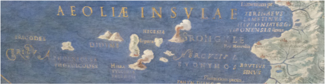 An overview of the Aeolian Islands. Comments are closed.
|
 Archives
July 2023
|
 RSS Feed